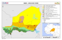
Les différentes zones en securité alimenatire:
NE01 - Northeast Oases: Dates, Salt and Trade
NE02 - Aïr Massif Irrigated Gardening
NE03 - Transhumant and Nomad Pastoralism
NE03 - Transhumant and Nomad Pastoralism-Camels
NE04 - Agropastoral Belt
NE05 - Rainfed Millet and Sorghum Belt
NE06 - Cropping/Herding with High Work Outmigration
NE07 - Southern Irrigated Cash Crops
NE08 - Southwestern Cereals with Fan-Palm Products
NE09 - Niger River Irrigated Rice
NE10 - Dallols - Seasonal Water-Course Irrigated Crops
NE11 - Southeastern Natron Salt and Small Basin Irrigated Dates NE12 - Komadougou Irrigated Peppers NE13 - Lake Chad Flood-Retreat Cultivation with Fishing Not Zoned (Desert)
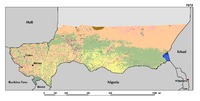
Driven by the rapid population growth and the increasing demand for food, agricultural expansion is the most dramatic change in Niger’s landscapes. Over the period 1975–2013, cultivated areas have increased from 12.6 percent in 1975 to 18.1 percent in 2000 and 24.5 percent in 2013. This represents a total increase of 94.2 percent. Agriculture expansion mostly occurred on the productive sandy soils of the valleys in the Tillaberi region, where cropland is now encroaching on traditional pastoral lands. On the surrounding plateaus and terraces of western Niger, a mosaic of steppe and short grass savanna dominates. The Zinder-Maradi region, already heavily cultivated in 1975, is now a wall-to-wall homogeneous agricultural landscape. However, agriculture is still expanding eastward on the remaining short grass Sahelian savannas of the Manga regions. In addition, an increase of 50 percent in irrigated agriculture was observed along the Niger River.