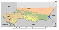
Driven by the rapid population growth and the increasing demand for food, agricultural expansion is the most dramatic change in Niger’s landscapes. Over the period 1975–2013, cultivated areas have increased from 12.6 percent in 1975 to 18.1 percent in 2000 and 24.5 percent in 2013. This represents a total increase of 94.2 percent. Agriculture expansion mostly occurred on the productive sandy soils of the valleys in the Tillaberi region, where cropland is now encroaching on traditional pastoral lands. On the surrounding plateaus and terraces of western Niger, a mosaic of steppe and short grass savanna dominates. The Zinder-Maradi region, already heavily cultivated in 1975, is now a wall-to-wall homogeneous agricultural landscape. However, agriculture is still expanding eastward on the remaining short grass Sahelian savannas of the Manga regions. In addition, an increase of 50 percent in irrigated agriculture was observed along the Niger River.
Sur la base d’analyse des observations climatiques historiques, d’analyse du climat futur, et de simulations à l’aide de modèles de cultures, cet atlas contient un ensemble de représentations cartographiques, graphiques et tabulaires qui permet de répondre aux questions que posent les citoyens sur les changements climatiques.
Les bassins sédimentaires d’Iullemeden et de Taoudéni-Tanezrouft couvrent une superficie d’environ 2,5 millions de km². Ils sont en continuité géologique et hydrogéologique et constituent un seul ensemble qui contient plusieurs nappes d’eaux souterraines logées dans des formations géologiques aquifères datées de l’ère Primaire jusqu’au Quaternaire.