
Recherche
6 items
-

Atlas Niger Ecoregions
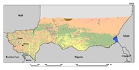
The Sahara Desert landscape, which covers about 65 percent of Niger, is made up of endless stretches of shifting sand dunes and broad gravel and stony plains. In years when the monsoon rains reach the southern Sahara, the wadis of the Aïr Massif and the plains of the Tamesna (TAM) are relatively more productive than the surrounding plateaus. To the south, the rest of the country is located within the Sahel, a transition zone between the desert and tropical West Africa. Across central Niger, from the Malian border to Chad, the pastoral zone of the Manga (MA1 and MA2) and Azouak (AZ) regions forms a wide strip of steppes and savannas. The Maradi-Zinder region (TRK and GLB) constitutes the largest agricultural region of Niger. In these ecoregions, the average bioproductivity gradually increases toward Niger’s southern border, where farmers are conserving trees in their fi by encouraging natural regeneration. In western Niger, the productive ancient alluvial valleys of the Bassin des Dallols (BD) contrast with the less productive steppes and tiger bush of the surrounding plateaus and terraces. -
Land cover changes
Driven by the rapid population growth and the increasing demand for food, agricultural expansion is the most dramatic change in Niger’s landscapes. Over the period 1975–2013, cultivated areas have increased from 12.6 percent in 1975 to 18.1 percent in 2000 and 24.5 percent in 2013. This represents a total increase of 94.2 percent. Agriculture expansion mostly occurred on the productive sandy soils of the valleys in the Tillaberi region, where cropland is now encroaching on traditional pastoral lands. On the surrounding plateaus and terraces of western Niger, a mosaic of steppe and short grass savanna dominates. The Zinder-Maradi region, already heavily cultivated in 1975, is now a wall-to-wall homogeneous agricultural landscape. However, agriculture is still expanding eastward on the remaining short grass Sahelian savannas of the Manga regions. In addition, an increase of 50 percent in irrigated agriculture was observed along the Niger River. -

Carte d'utilisation des sols dans la région de Zinder
Utilisation des sols dans la région de Zinder et représentation des isohyètes observés sur la période 1925-1957 -

Zones biogéographiques
La production alimentaire du pays est très largement fondée sur la culture du mil pluvial, qui reste à ce jour l’aliment de base. Or il s’agit d’un système de production traditionnel, de type semi extensif (défrichements et large recours aux jachères, fumure uniquement animale, culture manuelle), qui, autrefois très bien adapté aux contraintes écologiques et sociales, est aujourd’hui en crise profonde et sans doute irréversible. Les terres disponibles se sont raréfiées sous l’effet de la pression démographique (après le Libéria, le Niger a le taux de croissance le plus élevé du monde (1)). Dans les parties méridionales du pays, les plus fertiles autrefois, mais aussi les plus peuplées, la jachère a disparu et les terres sont épuisées. Tout au long du XXe siècle, la limite des cultures s’est déplacée vers le Nord, dans des zones plus vulnérables, à grands risques pluviométriques, et où d’incessants conflits, parfois meurtriers, opposent éleveurs et agriculteurs. -

-

Présentation du Niger
Le Niger est situé dans la zone sahélo- saharienne de l’Afrique (Voir carte), il couvre une superficie de 1.267.000 Km² soit deux fois la superficie de la France. Les pays limitrophes du Niger sont le Mali et le Burkina Faso à l’Ouest, le Bénin et le Nigeria au Sud, l’Algérie et la Libye au Nord, et le Tchad à l’Est. C’est l’un de pays les plus enclavé dans le monde : aucun débouché sur la mer, aucune voie ferrée. Cette continentalité constitue un handicap pour le développement socio-économique du pays.