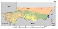
Driven by the rapid population growth and the increasing demand for food, agricultural expansion is the most dramatic change in Niger’s landscapes. Over the period 1975–2013, cultivated areas have increased from 12.6 percent in 1975 to 18.1 percent in 2000 and 24.5 percent in 2013. This represents a total increase of 94.2 percent. Agriculture expansion mostly occurred on the productive sandy soils of the valleys in the Tillaberi region, where cropland is now encroaching on traditional pastoral lands. On the surrounding plateaus and terraces of western Niger, a mosaic of steppe and short grass savanna dominates. The Zinder-Maradi region, already heavily cultivated in 1975, is now a wall-to-wall homogeneous agricultural landscape. However, agriculture is still expanding eastward on the remaining short grass Sahelian savannas of the Manga regions. In addition, an increase of 50 percent in irrigated agriculture was observed along the Niger River.
La région de Tahoua, couvre une superficie de 113 317 km2. Elle compte 8 départements. Cette carte présente les départements, les communes, les localités, les voies de communication de la région.
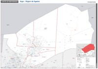
Avec 667.799 km², la région d'Agadez est incontestablement la région la plus vaste du Niger. Cette carte de référence présente les départements, les communes, les localités, les points d'eau, les routes... de la région.